Просмотр новости
Найдите то, что Вас интересует
 Спутники
 РН
РН SpaceX
 Роскосмос
 NASA
NASA
СпутникиРНSpaceXРоскосмосNASAAfrica’s Turkana Rift Zone has been caught in the act of “necking" — a key point in breakup of continental crust.
Sometimes, pieces of Earth’s outer layer pull apart like taffy. Right now, part of Africa is being stretched to nearly the breaking point.
The giant jigsaw pieces of Earth’s outer layer are called tectonic plates. Scientists knew that the plates beneath eastern Africa are being tugged apart. The crust there is already thin and weak in places. But new data show that one region — the Turkana Rift Zone — is undergoing “necking.” It’s a key part in the process of a continent breaking up and has never been seen before.
The new observations hint that this part of East Africa may be closer to splitting — and doing so more rapidly — than previously thought. Researchers shared their discovery April 23 in Nature Communications.
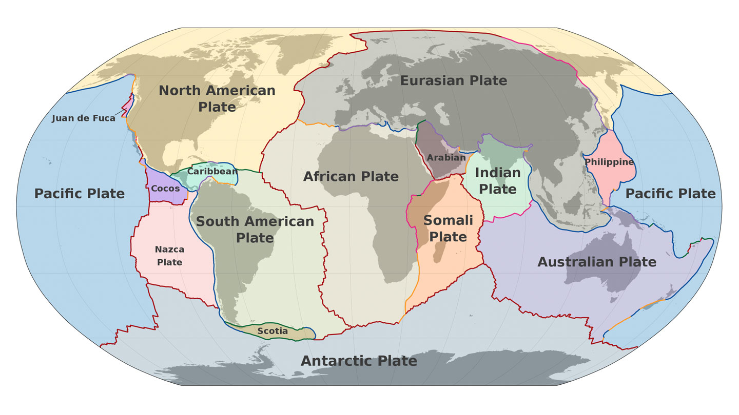 Our planet’s tectonic plates are constantly in motion. This research focuses on the pulling apart of the African and Somali plates.M. Bitton (CC BY-SA 3.0)
The Turkana Rift Zone straddles the countries of Kenya and Ethiopia on Africa’s eastern edge. The region is best known for its wealth of fossils of our human ancestors. But rocks beneath this rift zone hold their own secrets.
Christian Rowan studies Earth science at Columbia University in New York City. He and his teammates looked at past data on the Turkana Rift Zone. They included sound-based measurements that had been taken to search for oil and gas. Sending sound waves into the planet and watching how they bounce around can create images of what’s below, Rowan explains. “It’s almost like an ultrasound of the upper crust.”
The point of no returnThe team focused on a layer of metamorphic rocks beneath the planet’s surface. Those old, hard rocks form the crust under Earth’s continents. Rowan’s group traced those crustal rocks down to Earth’s mantle. They found one region where the crust was just under 13 kilometers (8 miles) thick.
That was a big surprise, Rowan says. The crust is usually about 30 kilometers thick. (That’s almost 19 miles.)
Earth’s crust had clearly been stretched a lot in the Turkana Rift Zone. That matched what scientists would expect in the necking stage of continental breakup.
“It’s kind of the point of no return,” says Sascha Brune. He works at the GFZ Helmholtz Centre for Geosciences in Potsdam, Germany, and did not take part in the research. He does, however, study how Earth’s interior and surface evolve over time.
Scientists have seen the aftermath of necking between tectonic plates elsewhere on Earth. But this process has never been observed in action. That’s what makes the Turkana Rift Zone so special, Brune says. “This is the place to go.”
See what’s causing East Africa to slowly split off from the rest of the continent, how that has affected the area’s climate and fossil record — and when a completely new island continent may emerge.Past and future stretchingRowan’s group wondered how long the Turkana Rift Zone has been in this breakup stage. To find out, they looked at a layer of volcanic rock that had once been at Earth’s surface. Over time, it has since been pulled down as the crust here has stretched apart and sunk in the middle. It shows the rift has been necking for roughly 4 million years.
The Turkana Rift Zone’s trove of fossils may exist due to that stretching and dipping. Sediments, some containing fossils, naturally build up in low-lying regions.
If the Turkana Rift Zone continues necking, it could enter the final phase of continental breakup. It’s a stage known as oceanization.
At that point, Earth’s crust tears, and the mantle beneath punches through. Magma from the mantle then oozes across Earth’s surface. Eventually, it cools and forms new oceanic crust.
Oceanic crust is denser than continental crust. So it tends to sink and collect water. (Hence why this dense crust is found beneath Earth’s oceans.) Water will now flow into the lower-lying parts. Over millions of years, an ocean could develop that would formally split off part of eastern Africa, creating a distinct landmass, Rowan says. “Eventually, eastern Africa will break apart.”
Submit your question here, and we might answer it an upcoming issue of Science News Explores
ancestor: A predecessor. It could be a family forebear, such as a parent, grandparent or great-great-great grandparent. Or it could be a species, genus, family or other order of organisms from which some later one evolved. For instance, ancient dinosaurs are the ancestors of today's birds. (antonym: descendant)
computer model: A program that runs on a computer that creates a model, or simulation, of a real-world feature, phenomenon or event.
continent: (in geology) The huge land masses that sit upon tectonic plates. In modern times, there are six established geologic continents: North America, South America, Eurasia, Africa, Australia and Antarctica. In 2017, scientists also made the case for yet another: Zealandia.
continental crust: (in geology) Rock that underlies most of Earth’s continents. It is less dense than ocean crust and sort of floats above ocean crust in regions where the two may meet and collide. This material is typically formed of rocks such as granite.
crust: (in geology) Earth's outermost surface, usually made from dense, solid rock (in planetary science) the outermost surface of rocky planets, dwarf planets and natural satellites.
fossil: Any preserved remains or traces of ancient life. There are many different types of fossils: The bones and other body parts of dinosaurs are called “body fossils.” Things like footprints are called “trace fossils.” Even specimens of dinosaur poop are fossils. The process of forming fossils is called fossilization.
geoscience: Any of a number of sciences, like geology or atmospheric science, concerned with better understanding Earth. People who work in this field are known as geoscientists.
landmass: A continent, large island or other continuous body of land.
magma: The molten rock that resides under Earth’s crust. When it erupts from a volcano, this material is referred to as lava.
mantle: (in geology) The thick layer of the Earth beneath its outer crust. The mantle is semi-solid and generally divided into an upper and lower mantle.
metamorphic: (in geology) A term for rocks that have been transformed by temperature, pressure, stress and/or chemical reactions. The former rock could have been igneous, sedimentary, or some other type of metamorphic rock.
model: A simulation of a real-world event (usually using a computer) that has been developed to predict one or more likely outcomes. Or an individual that is meant to display how something would work in or look on others.
necking: (in geology) A mechanical stretching, thinning and deformation of surface rock as the tectonic plates below begin to move apart.
rift: (v.) to break or split apart, such as a friendship. (in geology) The separation of a span of Earth’s surface along a geologic fault as a result of plate tectonics. (n.) The term for such a break or split.
rift zone: (in volcanology) An area where some volcano is splitting open, especially along its flanks. The rock here will be cracked and rather weak. That allows magma to push through it and to the surface. Once released from the rock, the lava will flow downhill, much as water would.
sediment: Material (such as stones and sand) deposited by water, wind or glaciers.
sound wave: A wave that transmits sound. Sound waves have alternating swaths of high and low pressure.
tectonic plates: The gigantic slabs — some spanning thousands of kilometers (or miles) across — that make up Earth’s outer layer.
trove: A collection of valuable things.
ultrasound: (adj. ultrasonic) Sounds at frequencies above the range that can be detected by the human ear. Also the name given to a medical procedure that uses ultrasound to “see” within the body.
wave: A disturbance or variation that travels through space and matter in a regular, oscillating fashion.