Просмотр новости
Найдите то, что Вас интересует
 Спутники
 РН
РН SpaceX
 Роскосмос
 NASA
NASA
СпутникиРНSpaceXРоскосмосNASAThe Met Office says there is no sign of a polar vortex directly hitting the UK, though El Niño and changes in the vortex could influence winter weather.
The UK is heading into a period of unsettled weather this week, but the Met Office says there is currently no indication that a polar vortex will sweep directly across the country. Instead, forecasters are watching how an unusually strong El Niño event could influence the jet stream and polar vortex, with wetter and windier conditions possible in the near term and colder spells becoming a possibility later in winter.
The latest forecasts come as meteorologists monitor what the Independent described as an unprecedented El Niño event in the tropical Pacific. The Met Office has said the phenomenon could have far-reaching effects on global weather, but it has also stressed that individual weather events cannot automatically be blamed on El Niño.
What the Met Office says about the polar vortexThe polar vortex is a large area of rotating winds high above the Arctic. It is not a storm that travels down from the North Pole and hits Britain like a normal weather system.
Instead, changes in the strength of the stratospheric polar vortex can influence atmospheric circulation lower down. A stronger vortex can be associated with a stronger jet stream, while a weaker vortex can sometimes increase the chances of colder air reaching the UK.
A Met Office spokesperson explained the difference clearly. "A stronger-than-normal polar vortex can favor a stronger jet stream, which may increase the likelihood of mild, wet and windy conditions," the spokesperson said.
"Conversely, a weaker polar vortex can sometimes increase the chances of colder weather affecting the UK."
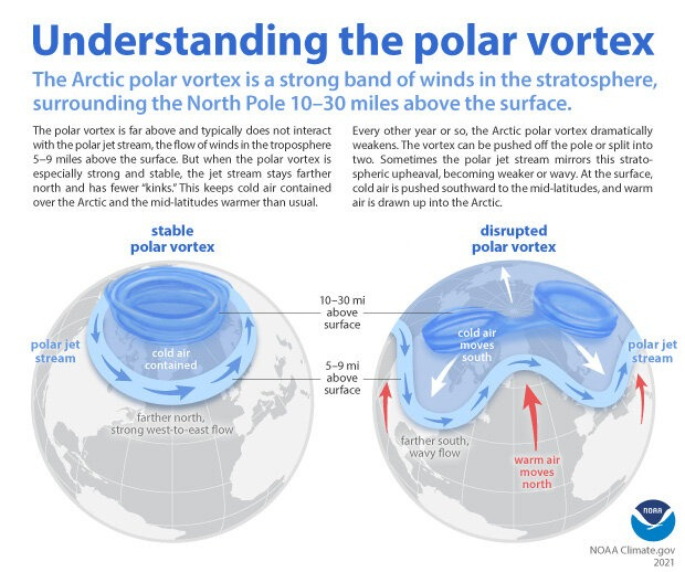 When the Polar Vortex is strong and stable, it keeps the Arctic’s coldest air contained at the top of the world.
NOAA
When the Polar Vortex is strong and stable, it keeps the Arctic’s coldest air contained at the top of the world.
NOAA
That means headlines about a polar vortex "hitting" Britain can be misleading. The actual concern is whether changes in the vortex alter weather patterns over the UK.
What could happen to UK weather this weekThe immediate forecast is not for an Arctic freeze. Instead, the Met Office is expecting unsettled conditions, with rain and strong winds possible in parts of the country.
Met Office deputy chief forecaster Dan Holley warned that a particularly deep area of low pressure could pass close to the UK during the first half of the week.
"While details are naturally uncertain at this range, a particularly deep area of low pressure could pass close to the UK during the first half of next week," Holley said.
"This may bring some wet and windy weather for some, which coupled with high spring tides, could bring impacts to some coastal areas in the west."
The Independent reported that heavy rain is expected across much of the UK on Wednesday, with flood warnings in place in parts of England, including East Yorkshire, Cumbria, Suffolk, Norfolk and West Sussex.
How El Niño could affect the UK laterEl Niño develops when sea-surface temperatures in parts of the tropical Pacific become warmer than normal. Because the Pacific Ocean is enormous, changes in its temperature can influence atmospheric circulation far beyond the region.
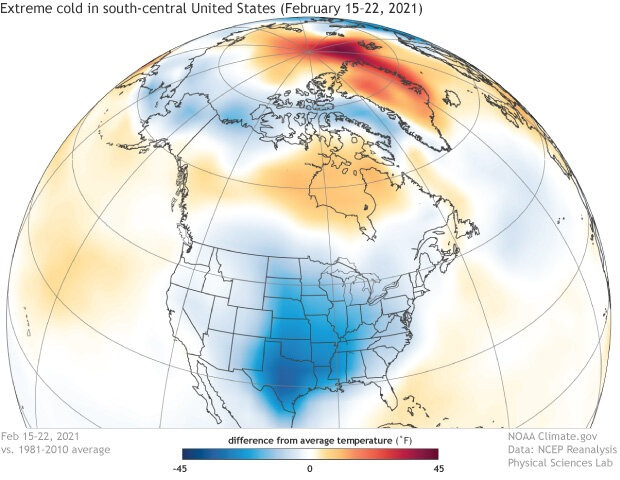 Near-surface air temperatures across the Northern Hemisphere from February 15–22, 2021, compared to the 1981-2010 average. The polar jet stream made a deep dive into the south-central United States, bringing extreme cold (dark blue) to the Southern Plains. Meanwhile, parts of the Arctic were much warmer than average (orange and red).
NOAA
Near-surface air temperatures across the Northern Hemisphere from February 15–22, 2021, compared to the 1981-2010 average. The polar jet stream made a deep dive into the south-central United States, bringing extreme cold (dark blue) to the Southern Plains. Meanwhile, parts of the Arctic were much warmer than average (orange and red).
NOAA
The current El Niño has been described as exceptionally strong. Professor Adam Scaife, head of long-range predictions at the Met Office, said scientists had been warning about its unusual strength for months.
"We have been signaling for months that the developing El Niño will be an unprecedented event. The fact that it has already exceeded previous records, with several weeks to go before it peaks later this year, shows the enormity of this El Niño," Scaife said.
"Scientists are still assessing whether the impacts will be in proportion to its magnitude, but we are already seeing expected effects worldwide."
However, a powerful El Niño does not automatically mean Britain will experience a major freeze.
Could Britain get a colder winter?The Met Office's long-range outlook points toward changeable weather, with Atlantic weather systems bringing periods of rain, showers and occasional strong winds. Temperatures are expected to be above average for the period as a whole, according to the Independent's report.
The bigger question is what happens to the polar vortex later in the winter. If the vortex weakens significantly, Arctic air can sometimes move farther south, increasing the possibility of cold spells in Europe.
This does not mean a major snowstorm or prolonged freeze is already forecast for Britain. Meteorologists have stressed that every El Niño event behaves differently, making the eventual UK impact difficult to predict this far ahead.
Why 2027 could also be importantThe effects of the current El Niño may extend beyond this winter. Met Office scientist Dr. Nick Dunstone said large El Niño events release additional heat from the ocean into the atmosphere, which can affect global temperatures particularly during the calendar year after the winter peak.
"During large El Niño events, significantly more heat is released from the ocean to the atmosphere, leading to an increase in global average temperature, particularly in the calendar year following the winter peak of the El Niño," Dunstone said.
"Hence, 2027 is very likely to replace 2024 as the warmest year on record and be yet another year to temporarily exceed +1.5 C above the pre-industrial period."
For now, the key message for the UK is that a polar vortex is not forecast to hit Britain in the coming weeks. The immediate concern is wet and windy weather, while forecasters will continue watching the El Niño and polar vortex for possible changes as winter approaches.
| # | Наименование новости | Тональность | Информативность | Дата публикации |
|---|---|---|---|---|
| 1 | SAY IT AIN'T SNOW: White stuff forecast next week in northern Ontario | 0 | 10 | 28-09-2026 |
| 2 | What will winter be like near you? Here's what the outlooks suggest | 0 | 5.62 | 28-09-2026 |
| 3 | What will winter be like near you? Here's what the outlooks suggest | 0 | 5.62 | 28-09-2026 |
| 4 | На юге европейской России ожидаются ливни, грозы и мокрый снег | 0 | 10 | 29-09-2026 |
| 5 | Стало известно о погоде в октябре в столичном регионе | 0 | 6.23 | 27-09-2026 |
| 6 | Super El Niño to bring rare heavy snow to 14 southern states this year | 0 | 10.91 | 25-08-2026 |
| 7 | Погода новой недели | 0 | 10 | 27-09-2026 |
| 8 | Зима в столице может начаться с аномального тепла | 0 | 12.07 | 29-09-2026 |
| 9 | Синоптик Ильин: в выходные в Московской области возможны заморозки | 0 | 10.36 | 29-09-2026 |