Просмотр новости
Найдите то, что Вас интересует
 Спутники
 РН
РН SpaceX
 Роскосмос
 NASA
NASA
СпутникиРНSpaceXРоскосмосNASAA strengthening El Niño could bring Florida a wetter, cloudier and stormier dry season. Here is why the risk of flooding, squall lines and tornadoes typically increases—especially across Central and South Florida.
Published October 6, 2026 at 7:46 AM EDT
A strong El Niño is expected to make this winter one of the wettest on record for Florida, bringing frequent rain, storms and a higher risk of severe weather, so snowbirds and vacationers should plan for wet, cooler conditions and have flexible indoor alternatives.
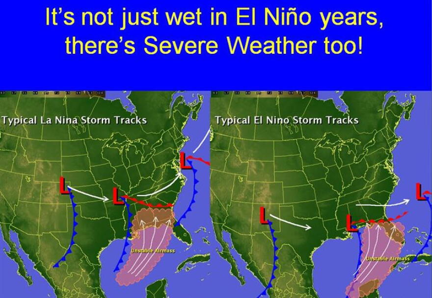
El Niño is rapidly strengthening and is expected to become very strong this fall. For Florida, that typically pushes the subtropical jet farther south, steering more clouds, rain and Gulf storm systems across the state from fall into early spring.
via National Weather Service
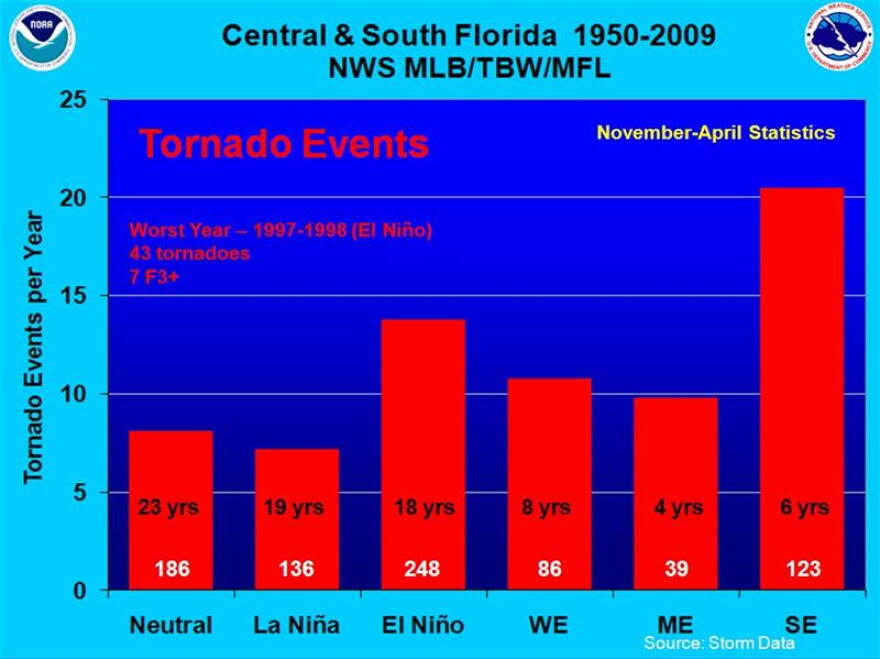
The most significant concern is severe weather. Historical National Weather Service data show Central and South Florida average nearly twice as many tornado events during El Niño winters, with the number rising further during strong events. The most sobering example is the 1997–98 Super El Niño, Florida’s wettest November-through-March period on record. It culminated in “The Night of the Tornadoes,” the deadliest tornado outbreak in state history.
The story will examine what previous Super El Niños brought Florida, why no two events unfold exactly alike and how increased rainfall could provide both benefits and hazards—recharging water supplies and reducing wildfire risk while increasing the potential for flooding, squall lines and tornadoes. It will also give Floridians practical steps for preparing for what could be a tumultuous fall and winter.
No shortage of tropical moisture inundating parts of Florida over the next 1-2 weeks! Heaviest will be in North FL and the Panhandle where up to a foot may fall in spots!!
— Jeff Berardelli (@WeatherProf) October 3, 2026
But no worries Tampa-Orlando you’ll get some good action too. A bit less in South FL. Nice way to end what’s… pic.twitter.com/9jrs69REPG
After a hurricane season defined by what has not happened, Florida’s weather may be preparing to shift gears. El Niño has helped suppress Atlantic hurricanes, but the same climate pattern often makes Florida’s fall and winter wetter, cloudier and more stormy. NOAA says this El Niño is likely to become very strong. Florida Storms meteorologist Leslie Hudson explains what that could mean for the state’s dry season.
And the tornado signal is not uniform across Florida. The National Weather Service says the El Niño increase is most pronounced across Central and South Florida. Farther north, winter severe weather remains a threat regardless of whether the Pacific is in El Niño, La Niña or a neutral pattern.
via National Weather Service
| # | Наименование новости | Тональность | Информативность | Дата публикации |
|---|---|---|---|---|
| 1 | Why Hurricane Isaias could trigger tornadic supercells across northern Florida | 0 | 6.4 | 09-10-2026 |
| 2 | El Niño’s role in the tropics and how it could impact weather patterns this winter season | 0 | 10.61 | 21-08-2026 |
| 3 | What flash droughts and a super El Nino will mean for your summer | 0 | 5.26 | 07-09-2026 |
| 4 | Will October end the Atlantic’s historic hurricane pause? | 0 | 7.51 | 03-10-2026 |
| 5 | Wet season starts in Hawaiʻi during El Niño, what to expect | 0 | 8.4 | 04-10-2026 |
| 6 | Florida Panhandle faces flood risk from heavy rain | 0 | 8.67 | 30-09-2026 |
| 7 | “El Niño” se podría convertir esta primavera en el fenómeno más potente de los últimos 40 años | 0 | 8.64 | 30-09-2026 |
| 8 | Super El Niño is here. What's so super about it? | 0 | 7.66 | 05-10-2026 |
| 9 | Super El Niño to bring rare heavy snow to 14 southern states this year | 0 | 10.91 | 25-08-2026 |
| 10 | A Very Wet Weekend Is Ahead | 0 | 8.75 | 02-10-2026 |