Просмотр новости
Найдите то, что Вас интересует
 Спутники
 РН
РН SpaceX
 Роскосмос
 NASA
NASA
СпутникиРНSpaceXРоскосмосNASA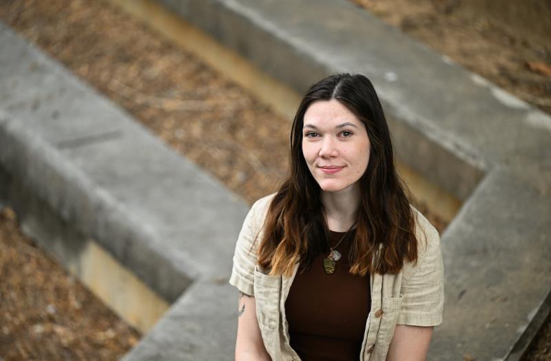
Alex Garretson
photo by Angela Foster/UTC
Alex Garretson, a 2025 University of Tennessee at Chattanooga graduate, is a geographic information system (GIS) technician at UTC’s Center for Applied Geospatial Data Science (CAGDS).
At the Tennessee Geographic Information Council’s annual conference in Franklin earlier this spring, Ms. Garretson took home the Best Spatial Analysis Award for her work developing a conservation decision support tool for Lula Lake Land Trust—an 8,000-acre land trust around Lookout Mountain, Ga.
The project, funded by the Open Space Institute, will help the nonprofit prioritize which lands to protect as it works to expand its conservation reach across a 100-mile stretch of plateau extending into Alabama.
Originally from Gallatin, Tn., Ms. graduated from UTC with degrees in environmental science and general mathematics. She has been a GIS technician at the center since 2024 and is planning to begin a master’s program in environmental science at UTC this fall.
As an undergraduate student focusing on biodiversity, a required GIS course opened her eyes to how central the field is to environmental work.
“Pretty much every environmental position that interested me involved some component of GIS,” Ms. Garretson said. “Then I switched my concentration to the geographic and cardiographicsciences.”
A faculty member encouraged her to apply for a job with the center.
“I interviewed with them and they’ve just been amazing people to work for,” she said.
The Lula Lake project got underway in October 2025. The ask: build a map to help the land trust determine where to focus its conservation efforts as it looks to grow beyond the Rock Creek Watershed.
That meant wading into one of conservation’s oldest debates: what exactly are you trying to protect, and from whom?
“There are two overarching ideas of preservation versus conservation,” Ms. Garretson explained. Preservation means leaving land entirely untouched; conservation acknowledges that people also need to use and benefit from the land.
Lula Lake’s mission straddles both. They protect habitats and build trails, so Ms. Garretson’s model had to account for both, too.
The map she built scores land equally on habitat value and outdoor recreation potential.
Habitat factors include the presence of endangered species, soil erodibility and slope. Recreation scores are based on proximity to trails, protected areas and Lula Lake’s current property. The two scores are combined into an overall conservation effort covering Dade, Chattooga and Walker counties in northwest Georgia.
Then there’s the development piece, which Ms. Garretson kept separate from the main model.
“We’re not anti-development whatsoever,” she said. “We want to be thoughtful about how we consider it when making conservation decisions.”
Instead of including development pressure into the overall score, she built it as a standalone layer that staff can pull up alongside the main model depending on what they’re trying to accomplish.
“If I had said all of these development factors are bad for conservation, that’s sort of telling my own narrative that might not necessarily be true for every situation,” she said. “By keeping that development model standalone, it allows people to see exactly where my final model is coming from—and then make their own call.”
CAGDS Director Charlie Mix expressed that this award means a lot to Ms. Garretson and the center.
“For Alex’s work to be recognized by TNGIC with this award is an honor that reflects both her skill and dedication as a young GIS professional,” Mr. Mix said. “Alex’s work with Lula Lake Land Trust is an impactful example of our effort to foster student growth by applying cutting-edge GIS tools and workflows to real-world challenges—work that will help the trust identify and advance conservation projects that protect Lookout Mountain’s rare ecosystems while expanding outdoor recreation opportunities for the Chattanooga community.”
Lula Lake’s leadership, Executive Director Cody Roney and Stewardship Director Patrick Kelly, worked closely with Ms. Garretson while she developed the project.
“You wouldn’t have known you were working with a student,” said Ms. Roney, a UTC alum who earned her master’s in public administration and nonprofit management in 2012. “She’s made it so easy for us.”
Ms. Roney and Mr. Kelly both said that Ms. Garretson put “her all” into the work.
“If anything, we’ve slowed her down,” said Mr. Kelly, who has taught trail building and management as an adjunct instructor at UTC.
He added that the partnership with CAGDS would have been hard to replicate elsewhere.
“They know this landscape,” Mr. Kelly said. “They can explain our mission just as well as we can. If we had tried to go to a private company, there’d be a lot of education we’d be paying for just to catch them up.”
Ms. Roney said the timing of the award made it even more meaningful.
“The project isn’t even finished yet and she’s already won an award,” she said. “That was a great thing to get to share with our grant funder.”
This fall, Ms. Garretson hopes to take over a research assistantship with the Chattanooga Tree Project in CAGDS as she begins her graduate coursework. She wants to develop her skills in remote sensing and drone work.
“I’ve gotten pretty well versed in spatial analysis, but remote sensing is a whole other piece,” she said. “This project was working entirely with data that already exists. Actually acquiring it and processing it is a whole other side of the coin. I’m excited to learn that.”
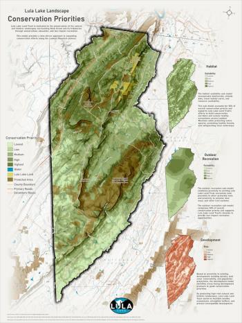
Alex Garretson's map for Lula Lake Land Trust photo by
| # | Наименование новости | Тональность | Информативность | Дата публикации |
|---|---|---|---|---|
| 1 | Lookout Mountain Conservancy Intern: I’m Not Chasing Easy, I’m Chasing Growth And Purpose | 5 | 7 | 30-05-2026 |
| 2 | Lookout Mountain Conservancy Intern: I Love The Growth, Hope And Future LMC Gave Me" | 8 | 7 | 27-05-2026 |
| 3 | У Курильского заповедника появилась подробная цифровая карта местности | 0 | 0 | 22-04-2020 |
| 4 | Cardwell Mountain State Archaeological Park Now Protects Region’s Heritage | 5 | 7 | 21-05-2026 |
| 5 | Горная графическая документация | 0 | 0 | 07-11-2025 |
| 6 | Литература по трассопоиску | 0 | 5 | 12-11-2023 |
| 7 | El camino hasta Oz | 0 | 0 | 29-05-2025 |
| 8 | Турмаршрут в Ингушетии к высокогорному водопаду благоустроят на грант Ростуризма | 0 | 0 | 22-12-2020 |
| 9 | Honoring the Life and Legacy of Dr. James R. Leutze | 0 | 10 | 20-07-2026 |
| 10 | Как географы АлтГУ проходят практику: 2000 км по Алтайскому краю и Республике Алтай — от заводов до живописных озер | 5 | 7 | 23-06-2026 |